Sources:MeteoAlarm · Open-Meteo · Copernicus · Sentinel-2 — high confidence · data 22:03
Sources & confidence
Sources
MeteoAlarm · Open-Meteo · Copernicus · Sentinel-2
Method
spearo sea-state engine: consensus of up to 6 models + satellite clarity (ZSD) + buoy-bias checks
Freshness
Re-read every hour, per coast
Compiled by the spearo sea-state engine · How it works →
The verdict comes from seven water factors and hard safety gates — not ten tabs. Go or stay.
How we score the water
Our own model
Our own forecast engine — not a third-party widget. It weighs these water factors into one go-or-stay verdict for this coast; the 0–10 dial is that verdict, read out as a number.
01
Swell & wave memory
Height, period and direction of the swell, plus the wake of recent storms — an old storm still stirs the water, and the engine remembers.
02
Wind & gusts
Speed and gusts, hour by hour — wind speed and an onshore push chop the surface and cut visibility.
03
Tide phase
Timing and range of the tide, calibrated per coast — big spring tides pull the verdict toward caution.
04
Water temperature
Sea-surface temperature — sharply cold water vetoes a green verdict.
05
Currents & outflow
Direction and drift of the current — it pushes you, and it drags turbid coastal water across where you dive.
06
Rain runoff & air clarity
Rain muddies the water inshore through land runoff, while fog and haze cut visibility at the surface.
07
Coast shape & exposure
How the coast faces the swell — a sheltered cove keeps the water clean; an exposed, head-on point takes a penalty.
Safety gates
Thunderstorm forecast — an instant red, no exceptions.
An official warning (MeteoAlarm / IPMA) — yellow, or red for the higher ranks.
Missing input data — a would-be green is capped to yellow rather than overstated.
Strong disagreement between forecast models — a green day is pulled back to yellow.
Night hours — where night spearfishing is banned by law the window is forced red; where it is legal (Australia outside NSW, New Zealand, South Africa) it is capped at yellow, never green.
It all folds into a single 0–10 score and one verdict: go or stay.
A forecast, not a guarantee — the sea has the last word.
Where to get in, where to hunt
Entry points with coordinates
Seabed relief — promising ground
This verdict — in your pocket. Open the app for the week's window.
point your camera
0 m
Surface
Wind, wave and the swell windows — when to go and the best hours.
spearo.app
MeteoAlarm no dataupdated 22:03
Poros — solo, off the rocks
BEST WINDOW
best weather window · solo, stay careful, run the checklist · calm conditions: swell, wind and visibility all normal
What's missing? Tell us what you'd like to see — new spots, species, data or features. We read everything.
Your best window — with you. Forecast in your pocket.
point your camera
−10 m
The water column
Visibility and what drives it — post-storm clearing, river plume, temperature and the thermocline.
What it is
A marine instrument, go / no-go for solo hunting.
spearo.app folds wind, wave, swell period, visibility, tides, water temperature and risk into a single verdict — go to the spot or not. It computes 7 days ahead from open marine models (Open-Meteo, IPMA), with no sign-up and no accounts. Built for solo spearfishing off the rocks, where any mistake costs dearly.
Now live: 3016 spots across 406 stretches of coast — mainland Portugal, Madeira and the Azores.
Work from first light, while the beach is empty and the water-sports school has not put its boats out. By midday the sea breeze gets up and the bay clouds from the shorebreak. The season opens on the first of June — all of May is closed in Greece. Night is banned, sunset to sunrise. September and October are best.
tide
Tides in the Aegean barely count — the level moves ten to forty centimetres and that changes nothing for you. What counts is different: after a few days of east wind the water is pushed into the bay and drains back along the edges, right at the sand-posidonia boundary, carrying the murk out deeper.
shelter
The bay opens straight east and that is its weakness: the island's bad sector, 40 to 150 degrees, walks right in, and an easterly around a hundred degrees is the worst of it. The headlands at either end shelter only their own corners. With west or north-west the island's spine stands as a wall and the bay lies down.
conditions
Come with west, north-west or south-west: then the bay is glass and you get the eight to fifteen metres of visibility Poros is capable of at all. With an easterly do not bother — between zero and fifteen metres the wave lifts sand off the edges of the posidonia and visibility drops to two or three metres.
hazard
Askeli is an organised flagged beach with loungers and a ski school: in summer keeping the 200 m off swimmers is genuinely hard here. Move outside the beach strip, onto the rocky ends of the bay, and keep your buoy high — the ski boats and jet skis move fast and look ahead badly.
access
It is a couple of kilometres from Poros town over the saddle on tarmac, with parking along the beach road. You enter over sand and stay knee-deep for a while — put your fins on afloat. Ten to fifteen minutes of swimming gets you to the rocky ends of the bay. The island's dive centre sits right on Askeli as a landmark.
E-facing bay, rock/sand/posidonia margins 0–15 m, shore/boat; sheltered, the best clean shore option. Coords approx.
You have to get up earlier here than at any other Poros spot: by about ten the water-sports school puts out jet skis and the ski boat, and the strip becomes unusable. The season starts on the first of June, all of May is closed, night is banned. October is the best month here — the school has shut by then.
tide
Forget the level. What you count is the pull out of the Poros narrows: the channel between the town and Galatas is about two hundred metres wide, and the flow squeezed through it reaches this shore as a weak echo — most noticeable along the rocky ends of the beach, where the depth picks up.
shelter
A straight west-facing shore, not a bay: the ridge at your back is the whole shelter, so an easterly leaves it calm, but there are no arms of land to hide behind from a westerly. What saves it is the narrowness of the channel — the mainland opposite cuts the fetch, so a west wave comes short and nasty but low.
conditions
Like Russian Bay it works on east days, when Askeli is churned up. But the water goes off faster here: the bottom near the shore is sand and fine pebble, and a fresh westerly lifts it along the whole strip. Visibility on this shore is the most temperamental on the island.
hazard
The danger here is not depth but the propeller: jet skis, the wakeboard boat and tow runs go right along the shore and do not expect a man in the water. Keep the buoy over your head, not on a long line. Add the hotel strip with swimmers you owe 200 m, and the boats heading for the channel.
access
A kilometre and a half to two along the west coast road out of town, a bus runs, parking by the tavernas. You enter off sand and fine pebble and can put your fins on ashore. The rocky ends of the strip are about three hundred metres either way, ten minutes of swimming; Mikro Neorio next door is the same shore but quieter.
Rocky W shore near Neorion; sea bream and saddled bream, boat traffic.
Leave the harbour before dawn so that you are over the drop-offs at sunrise — you may only shoot in daylight anyway. By midday the wave gets up on the open side and the anchored boat starts to work. The season starts on the first of June, all of May is closed. September and October are the best days.
tide
Tides do not count, but the water genuinely runs past the headlands of the south shore. After a few days of wind the along-shore flow strengthens and speeds up over the spurs, where the drop comes closest to the surface. You work from a boat here, so drop the buoy first and watch where it goes.
shelter
The open south side of the island: there is no bay to hide in, the only shelter is the ridge at your back. With north and north-west it is dead calm under the cliffs, the wind goes over the top. Easterly swell wraps around the eastern tip and reaches the outer drop-offs, and a southerly hits them head-on.
conditions
Your working day here is north or north-west: then the water stands still under the southern cliffs and you see further down the drop-offs than anywhere else at Poros. South-east and south out of the bad sector shut the trip down completely — the coast is open and the swell lives on for a day after the wind has dropped.
hazard
Modi islet to the south-east and the water around it are a declared underwater archaeological site with a Mycenaean wreck. A speargun is banned there, full stop: you do not approach Modi with a gun at all. Work the southern drop-offs west of the islet. Add open sea and the fast craft running to Hydra.
access
Boat only: there is no road to the southern cliffs and climbing down the rock is not an option. From Poros harbour, round the eastern tip, it is fifteen to twenty-five minutes. The coordinates in the card are the centre of an area, not a mark: find the individual drops with a sounder along the shore, they run as a band.
Rocky drop-offs on the open S side, boat; the real fish ground. Keep well clear of the protected Modi islet Mycenaean wreck to the SE. Area-centroid coords.
Get here early: by ten the canteen, the loungers and the first swimmers arrive, and in July and August the bay fills with yachts at anchor. The season runs from the first of June — all of May is closed across Greece. Night is banned, sunset to sunrise. The quietest weeks are late September and October.
tide
Level means nothing here. What works is different: in the gap between Daskalio and the shore the water squeezes and pulls in a steady thread, weak but visible on your buoy. After rain a brown trail comes down the pine gully at the head of the bay and a murky layer sits on the bottom along the point for a day or two.
shelter
A west-facing bay behind the island's back, with the little chapel islet of Daskalio guarding its mouth. The easterly that kills Askeli arrives here only after crossing the ridge and barely reaches the water. Pines run down to the shoreline and take the rest. The one open direction is west.
conditions
You come here exactly when an easterly has shut everything else on the island: at a hundred degrees the water is still workable in this bay. What breaks it is a hard west or south-west setting into the mouth — it lifts sand off the shallow head of the bay and turns eight metres of visibility into three within an hour.
hazard
In summer the bay is a yacht anchorage: you may not go within 200 m of a vessel at anchor, and chains and lines run far out under water from the hull. On the shore and at the waterline lie the ruins of the nineteenth-century Russian station — stone, masonry, iron; lift nothing and do not crawl under rubble after a fish.
access
The road runs along the west coast out of town, about ten minutes on a scooter; you leave the car up among the pines and walk down a path to the water. You get in over rock and pebble, so wear boots. Daskalio islet is a few minutes' swim away, but do not cross the gap broadside — boats run through it into the bay.
Sheltered W bay with the Daskalio chapel islet, rock/sand, shore/boat; calm and scenic. Coords approx.
If you come to look rather than to shoot, take the early morning, while the sun is low and the paved streets read on the bottom. The Greek season opens on the first of June, all of May is closed and night is banned — but at this bay all that is secondary: nobody hunts here in June or in October either.
tide
Level plays no part here. The bay is shallow and closed, so the water warms and stands; after rain or a hard northerly a fine silt lifts off the bottom, settles slowly and hangs over the slabs for days. Stirring up the mud over the ancient masonry is the easiest thing in the world.
shelter
A north-facing bay of the island, covered by headlands on both sides; the east sector barely gets in, the eastern tip cuts it off. It is open to north and north-west, and from there a short nasty wave runs in across the channel. The bottom is gentle, with rocky edges down each side of the bay.
conditions
On wind alone the bay would work with south and south-west, when the ridge covers it completely, and fall apart with a northerly. But there is no point coming here with a gun at all: the site is under archaeological protection, and the only thing allowed is a mask and snorkel, with no weapon in the water.
hazard
What matters here is not the ground or the boats but the law: a sunken ancient settlement lies on the floor of the bay — paved streets and house foundations, clearly visible through a mask. This is a declared underwater archaeological area and a speargun is banned in it. Lift nothing and do not touch the masonry.
access
A narrow tarmac road brings you over from the south side of the island, with the last stretch on dirt under the pines; you leave the car above and walk down to a small beach with a canteen and a couple of loungers. You enter over sand and the ancient slabs are a few dozen metres out — no long swim.
North-coast bay of Poros with rocky edges; sea bream and octopus, sheltered.
SOLO is the biggest risk: underwater you can black out from lack of oxygen silently and fatally, with no one around. Solo is never truly «safe». Below are the best weather windows; carry a buoy, tell someone your plan and exit time, and any doubt — don't go.
One morning glance — and you know.
point your camera
≈
Surfacing
Cameras, map and reference — to hand as you come up.
Live cameras, map & reference
Cameras · live
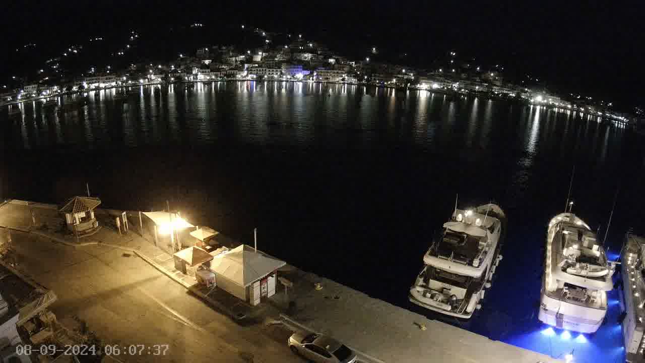
Look at the water right now.
Check the cam BEFORE you leave. Foam, brown/green murk, or waves washing the entry rocks = No-go. At night/in fog the cam is useless — treat it as «unknown», NOT «green».
Poros — Poros–Galatas strait (saronic-cameras)Refreshing still — Poros–Galatas strait. A live sea view (not video). Read the water before you go.camera: saronic ↗
National minimum sizes + a 150 g floor (in the table below); grouper 1/day. Spearfishing is closed all May (ΠΔ 373/1985).
In season now
white seabream
Diplodus sargus · 0–12 m · EU 1967/2006
common octopus
Octopus vulgaris · 0–15 m · weight ≥750 g
Minimum by weight: ≥750 g (ΠΔ 62/2024). Don't take egg-bearing females.
dusky grouper
Epinephelus marginatus · 8–35 m · EU 1967/2006
Grouper: max 1/day (shared genus-Epinephelus limit).
common dentex
Dentex dentex · 12–40 m · min 150 g
Premier reef target. No EU size — the 150 g minimum only. Ethical ≥40 cm (not law).
red porgy
Pagrus pagrus · 15–40 m · EU 1967/2006
gilthead seabream
Sparus aurata · 2–20 m · EU 1967/2006
European seabass
Dicentrarchus labrax · 0–15 m · EU 1967/2006
saddled seabream
Oblada melanura · 3–15 m · min 150 g
No EU size — only the 150 g minimum applies.
greater amberjack
Seriola dumerili · 5–30 m · min 150 g
No EU size — only the 150 g minimum applies.
leerfish / garrick
Lichia amia · 2–20 m · min 150 g
No EU size — only the 150 g minimum applies.
Mediterranean barracuda
Sphyraena viridensis · 3–25 m · min 150 g
No EU size — the 150 g minimum only. Histamine: bleed and chill at once.
flathead grey mullet
Mugil cephalus · 0–8 m · min 150 g
No EU size — only the 150 g minimum applies.
striped seabream
Lithognathus mormyrus · 2–15 m · EU 1967/2006
brown meagre / corb
Sciaena umbra · 5–30 m · EU 1967/2006
striped red mullet
Mullus surmuletus · 3–30 m · EU 1967/2006
white grouper
Epinephelus aeneus · 15–45 m · EU 1967/2006
Grouper: max 1/day (shared genus-Epinephelus limit).
goldblotch grouper
Epinephelus costae · 10–35 m · EU 1967/2006
Grouper: max 1/day (shared genus-Epinephelus limit).
wreckfish / stone bass
Polyprion americanus · 30–60 m · EU 1967/2006
Deep wreck species. Does NOT count toward the grouper limit (different genus). 45 cm — to verify.
Mediterranean parrotfish
Sparisoma cretense · 2–20 m · min 150 g
Eastern-Med delicacy (Crete/Dodecanese). No EU size — the 150 g minimum only.
devil firefish (lionfish)
Pterois miles · 5–40 m · invasive
⚠️ Invasive — removal encouraged, excellent flesh. Venomous spines: never grab bare-handed, cut the spines, treat a sting with hot water (>45 °C).
silver-cheeked toadfish
Lagocephalus sceleratus · 5–40 m · invasive
☠️ Invasive — kill, but DO NOT EAT: deadly toxin (TTX). Sale banned (Reg. 853/2004, Annex III Sect. VIII Ch. V(E)). Powerful beak bites — never string it live on a stringer.
rabbitfish
Siganus rivulatus / luridus · 2–20 m · invasive
Invasive — removal encouraged, edible and tasty. Venomous dorsal/anal/pelvic spines — remove carefully, treat a sting with hot water.
Law
✓⚠️ MAY — a TOTAL spearfishing ban for the whole month, every year (ΠΔ 373/1985, art. 3§1α). This is law in force, not a draft.
✓No licence required: the was abolished in 2014 (Ν. 4256/2014) — every standing prohibition stays in force all the same.
•Recreational-fisher registry (ΟΣΠΑ / Μητρώο Ερασιτεχνών Αλιέων): Reg. (EU) 2023/2842 obliges member states to register recreational fishing, and the Greek registry is described as being prepared. We found neither an act in force nor a working registry as of 08.2026 — not confirmed. Check gov.gr before you travel.
✓Age: 16+ (under-16 spearfishing is forbidden; ΠΔ 373/85, art. 3§1γ).
✓Daytime only: sunrise to sunset. Night is forbidden (ΠΔ 373/85, art. 3§1β).
✓Freediving only: scuba/any air-supply apparatus is banned — it may not even be carried aboard (ΠΔ 373/85, art. 3§2γ).
✓Distances: ≥200 m from bathers, harbours, moored vessels and marked nets; no hunting in fairways or harbour entrances/exits (ΠΔ 373/85, art. 3§1δ/ε).
✓Buoy MANDATORY: a yellow float + a yellow flag with a red diagonal stripe and the letters «Υ.Δ.», visible from ≥300 m; stay within 50 m of the buoy (ΠΔ 373/85, art. 3§3).
✓Limit: 5 kg/day (or one trophy heavier than the limit). Grouper (Epinephelus) — max 1/day, not banned (ΠΔ 373/85, art. 2§2).
✓Sale/trade of the recreational catch is prohibited (ΠΔ 373/85, art. 1§7).
✓Load the speargun only in the water — never keep it loaded out of the water (ΠΔ 373/85, art. 3§2β). Underwater light while hunting is forbidden (art. 3§2ζ).
✓Sea urchins — 20/day per person and 30/day per boat (ΠΔ 373/85, art. 2§2). Nets at any stage of the hunt are banned, and you may not take the catch out of somebody else's gear or nets (art. 3§2). Sponges and corals are off limits to the recreational fisher (art. 1§6).
✓Pneumatic and band guns are ALLOWED (a myth in English guides). Only spears with an explosive/chemical charge — — are banned (ΠΔ 373/85, art. 3§2δ).
Min. sizes: seabass 25 cm · gilthead 20 cm · white seabream 23 cm · grouper 45 cm · octopus 750 g (ΠΔ 62/2024). Any fish — not under 150 g (ΠΔ 373/85, art. 3§2στ). No-size species (dentex, amberjack, barracuda, parrotfish) — the 150 g minimum only. See the species card.
Safety protocol
Sets: watch the wave trains ≥15 min before entering; Hmax ≈ 2×Hs, the wash can run 50 m past the foam line. A lull >10 min with period >12 s = a big set «overdue», do NOT enter; enter right after a full set passes and re-check at minute 30.
Exit FIRST: find your exit AND a backup before entering. On a rocky/boulder shore a 0.5 m rise in swell can make the exit impossible — getting pinned/unable to climb out is the main killer.
Headland rip: prominent points often have a permanent topographic rip regardless of the model — locate it, enter/exit on the windward side, never swim against it.
Cold: wetsuit per the SST chip; the first shiver = a metabolic surge and a drop in breath-hold → get out at the first steady shiver. Cap the session at 45–60 min below 15 °C.
Solo discipline: buoy up; tell someone the spot and exit time; conservative breath-hold (never push it in cold/murky/surfy water); visibility <3 m — don't enter.
Afternoon wind: on many coasts the wind builds from midday — plan to be out of the water by midday; the chop builds — get out.
UV 11:00–15:00 (UVI ≥6): sunscreen and cover up on the surface interval.
Solo is a fundamental risk (hypoxic blackout with no buddy). Any doubt = No-go.
FAQ — spearfishing in Poros
Where can I spearfish in Poros?
Poros has rock entry points such as Askeli (E coast), Russian Bay / Daskalio (W) and Poros south coast (toward Modi). A narrow channel town and Argo-Saronic reefs: calm, sheltered and ideal for learning, but the water is only fair (viz 8–15 m) and the good sites are archaeology-locked. Below you'll find each spot (access, shelter and hazards) and today's forecast.
When is the best season in Poros?
Long season, June to October (May is the national closed month). The sheltered Saronic opens on most calm mornings; peak is high summer.
How cold is the water in Poros?
Warm mediterranean water (~24–26 °C in summer, ~15 °C in winter), tideless; clear over rock but murkier near Athens' shores.
Is Poros good for a beginner?
Easy access and mostly sheltered water — a good place to start, with rocky capes and islets a short hop from the city.
Do I need a licence in Poros?
No paid licence is needed in Poros — the amateur one was abolished (Law 4256/2014), but a free ΟΣΠΑ registration is being introduced (check gov.gr). Breath-hold only (no scuba), a mandatory «Υ.Δ.» buoy, 16+, daytime only, and the whole of May is closed. See the guide.
Which fish can you spear in Poros?
The species cards list 22 species with real presence in this basin; the strongest here are white seabream, common octopus, dusky grouper, common dentex, red porgy and gilthead seabream. Minimum sizes in Greece are NATIONAL, not local: white seabream 23 cm · dusky grouper 45 cm · red porgy 18 cm · gilthead seabream 20 cm · European seabass 25 cm · striped seabream 20 cm · brown meagre / corb 25 cm · common octopus 750 g. Species with no EU size carry the 150 g floor only. Grouper (Epinephelus) — max 1/day, not banned (ΠΔ 373/85, art. 2§2).
Is spearfishing banned in May in Poros?
Yes. May is a TOTAL spearfishing ban for the whole month, every year, across Greece (ΠΔ 373/1985, art. 3§1α) — so in Poros too. It is law in force, not a draft, and there is no local exemption. Plan June to April.
How many kilos of fish may I keep per day in Poros?
The daily limit is 5 kg, or one trophy heavier than the limit (ΠΔ 373/85, art. 2§2). Grouper (Epinephelus) — max 1/day. Every fish must be at least 150 g (art. 3§2στ), and selling a recreational catch is prohibited (art. 1§7). The limit is national — in Poros it is the same as everywhere in Greece.
✓Full ban on taking: Pinna nobilis (πίννα), corals and sponges (ΠΔ 373/85, art. 1§6 + Habitats Directive 92/43).
✓Invasives: taking the lionfish (λεοντόψαρο) is encouraged — ⚠️ venomous spines. The silver-cheeked toadfish (λαγοκέφαλος) ☠️ DO NOT EAT — deadly toxin (TTX), sale banned (Reg. 853/2004, Annex III Sect. VIII Ch. V(E)), it bites. The rabbitfish (γερμανός) is edible — venomous spines.
✓In ANY declared underwater archaeological site, and in the submerged historic sites, spearfishing is BANNED — the act names ψαροντούφεκο in so many words (ΚΥΑ ΥΠΠΟ/ΓΔΑΠΚ/ΑΡΧ/Α1/Φ41/11228/1865, ΦΕΚ 336/Β/2004, part Α §2 δ + part Β). It reaches the sites our map does not draw, too. Do not touch antiquities (Ν. 3028/2002). Map of the zones — the ENALIA geoportal (thalchor-2.ypen.gov.gr/layers/geonode:ENALIA).
•The national marine parks of Alonissos/N. Sporades and Zakynthos (Laganas): spearfishing is BANNED in the park. But Alonissos zone Β4 is not solid — ΦΕΚ 1741/Β/2011 reopened four stretches inside it (the N shore Αγ. Δημήτριος–Άκρο Απύθμενο, Μηλιά–Σπαρτίνες, όρμος Κλήμα on Περιστέρα, the Μεγάλος Αδελφός shore), while the same act creates the ΕΕΑΧ Περιστέρας, where fishing IS banned. Our layer paints the park whole, i.e. stricter than the act. Check the limits with the park authority.
•The Southern Kynouria/Arcadia diving park: Ν. 4688/2020 establishes underwater parks, but we have not read a spearfishing prohibition inside it in the act — we treat that as NOT PROVEN rather than as confirmed. The park's boundary is not on our map either (the act publishes no coordinates). Ask the Leonidio/Tyros λιμεναρχείο before you go.
•Local bans: on top of the national rules, every port authority issues its own (ΓΚΛ/ΕΚΛ and λιμενάρχης decisions). In the ΛΣ-ΕΛ.ΑΚΤ registry we counted ~163 of them that reach a speargun, across 48 ports — our map does NOT draw them. Check your own port: alieia.hcg.gr/prohibitions/local/local17.php.
•Locally STRICTER than the national rule: Corfu (Kerkyra) — from 01.04 to 31.10 spearfishing is banned within 200 m of the shore, even where nobody is swimming (απόφαση Λ/Χ Κέρκυρας 2141.1/2939/2024, ΦΕΚ Β΄3269/2024). In practice that closes shore entry on Corfu for the season. We read the act in the registry, not in the ΦΕΚ — confirm with the λιμεναρχείο.
•Locally STRICTER: Lefkada — 300 m instead of 200, and not only the speargun: ψαροντούφεκο, nets and longlines are banned within 300 m of those sea areas, beaches and shores of the port district THAT ARE USED BY BATHERS (απόφαση Λ/Χ Λευκάδας 2131.13/1477/2022, in its own words «όπου χρησιμοποιούνται από λουόμενους»). The act ran to 30.09.2022 and we found no extension; an expired act is not proof that the ban is gone. Ask the Lefkada λιμεναρχείο.
•Locally STRICTER: Symi — from 15.06 to 15.09 fishing BY ANY MEANS is banned within 200 m of beach areas and in inhabited coastal areas WHERE BATHERS ARE PRESENT OR GATHER (απόφαση Λ/Χ Σύμης 2131.13/882/2016). Separately, year-round: fishing by any means is banned inside the port and its sea zone, except line/rod fishing from land (ΓΚΛ Σύμης, art. 151, ΦΕΚ 362/Β/2004). The acts were copied from the registry, not checked against the ΦΕΚ.
•Locally: inside the ports of Lavrio and Kea spearfishing is banned across the WHOLE port water, not merely under the 200 m rule; separately, in front of the hotel beaches (ΓΚΛ Λαυρίου, art. 240, ΦΕΚ 460/Β/1978). The act was copied from the registry, not checked against the ΦΕΚ.
•Coming: two new national marine parks are being created (Ionian + South Cyclades, ~27,500 km²). NOT yet in force (ΠΔ under review, mid-2026). Once live — a trawl ban + a seasonal coastal closure 15.04–31.05; in the strict zones spearfishing will be banned. Check before the season.
⛔ Pinna nobilis (πίννα, fan mussel) — full ban on taking/killing (Habitats Dir. 92/43 Annex IV; critically endangered).
Rules change, and the local Λιμεναρχείο (port authority) may impose local restrictions. Before heading out, check the current rules and the declared archaeological zones (ENALIA).
Can I spearfish on scuba in Poros?
No. Freediving only: scuba and any air-supply apparatus are banned — they may not even be carried aboard (ΠΔ 373/85, art. 3§2γ). In Poros the rest of the national frame applies too: 16+, daytime only, ≥200 m from bathers, harbours, moored vessels and marked nets, and a mandatory «Υ.Δ.» buoy you stay within 50 m of. Pneumatic and band guns are allowed; only powerheads are banned.